Posted by Iain on 05 Oct 2019, 18:24
Good evening Captain…, and thank you BB for that image. That makes things easier !
I’m treading lightly here as I’m not a ‘traditional’ model maker and I don’t want my remarks to negatively influence anyone’s work. (my models being in general 10mm high) And as BB said, I suppose the underlying philosophy for all members here differs from one person to another. So please don’t take my comments to heart; I’m only transmitting what I’ve learned over the years, plus a lifetime of Scots Guards Waterloo lamp-swinging.
Next week I’ll experiment with BB’s site concerning images ! If I manage to master it, I’ll post my updated version of the Adkin’s sketch.
“Secondary” or not…, it’s much more accurate than Siborne. (Siborne didn’t have satellite radar)
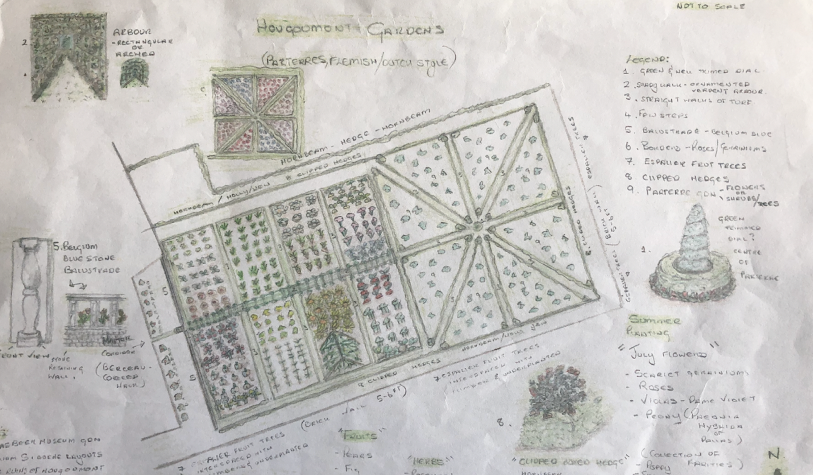
If you take a photocopy of Adkin’s sketch, then use Photoshop (or the equivalent) and place it over a Google Earth Map, you’ll find it fits perfectly. Then, superimpose the radar images, and it suddenly confirms Adkin’s kitchen gardens and even provides, for example, the western kitchen garden’s divide and the flood to the north. (long-gone, well before Siborne’s model; due to the farm changing from apples to cows)
As for the exterior hedgerow…, you are quite correct ! In fact, there were four openings !
Let’s put ourselves on Jérôme’s charger and we’ll all look through his telescope. (lol…, we have a northerly wind behind us according to Wellington; I mention that for your smoke)
As we look left, we see the distant poplar trees, (‘light green,’ each side the Chemin du Goumont) as the lane moves north towards the Nivelles Road. On the other side of that road is Braine L’Alleud. (in those days, unlike today, that track did not veer right around the field where the ponds were)
As we scan right from the light-green leaves, the western kitchen garden’s ‘hawthorn-green’ hedgerow, (about 50 yards from the north gate) starts its southerly move down to the first SW opening. This is the track leaving the southern apple orchard. We continue to scan right and once again, we see the second opening leaving the SE corner of the southern paddock, leading to La Belle Alliance. (‘behind us to the right’) No proof; however, it is said that this gate/opening had a small roadside chapel.
The hedge then moved north, up the eastern side of the two paddocks and the great orchard. Once again, halfway up, we have the third opening, where the southern lane moves east and out onto the rye fields on the right. It was on this corner that the French Pioneers started to uproot the hedgerow to gain access to the orchard.
Please also note that this southern lane (dividing the farm in two) had a northern-side hedge:
Important: As seen in Adkin’s image, and confirmed by radar, this hedge made up part of the great orchard’s southern hedgerow. (with a barricaded gate by the Grenadier Guards on the evening of 17th) IN ADDITION, this great orchard’s southern hedge was slightly further south than the formal garden wall. Because of it, the space between the western bound hedge and the garden wall; this space became the southern kitchen garden. And as it was open on its western end, it automatically joined up with the killing zone.
Lol…, of course, Van Cutsem could also have planted cabbages in front of his offices, but as Madame Dumonceau was a bit of a snob and relished her husband’s Flemish flower garden, I doubt if her gent friends and neighbours would have appreciated a vegetable patch. However, she just might have accepted strawberries !
In the meantime…, I have an ice-house and a bandstand there ! Typical for the snobs in the region; however, radar images tend to put it on the left of the flower beds.
Anyway, getting back to the main hedgerow; it then moved up towards the sunken lane ! At this point, turning left according to Craan, the hedgerow was not part of the sunken lane, it was a continuation of the same exterior hedge, bordering both the northern sides of the great orchard and the orchard strip.
As seen in Craan’s map, there’s no wooded area to the north of the lane like today, nor is there a northerly hedge…, the lane’s edge and stream gave directly onto the ridge. (the one that Matthew Clay fell into at 19h30 on the evening of the 17th)
Suddenly, this orchard hedge then stops, when the sunken lane does a 90° turn north towards Braine L’Alleud. And there, as you say, we have a fourth ‘gap.’ (having done a complete circle of the farm, the ‘gap’ is between the sunken lane and the northern tip of the western kitchen garden) One ‘single’ hedge !
However, I’m convinced (and I have the proof) that the three ponds on the northern pasture (right over the Waterloo Uncovered trench where Phil Harding told me he found a ton of plastic…, totally normal) the area there was flooded; and because of it, there was no access through this ‘gap’ for Jérôme. (infantry and especially cavalry would have kept well clear of it)
This was surely the reason why Jérôme did a right flanking attack on the farm…, despite putting himself in full view of more than half the Allied artillery. But that’s another story !
Must run ! I’m at Plancenoit for the time being. (my daughter’s house) Must fly.
Once again…, great work !
Kind ReGuards…, Iain.


 animal bladders filled with oil or fat. BB


